Landscape as Infrastructure

In the 21st century, it seems waste will be the new food.

Once the sole purview of the profession of civil engineering, infrastructure- which includes the management of water, waste, food, transport, and energy- is taking on extreme relevance for landscape planning and design practices in the context of changing, decentralizing structures of urban-regional economies. Food production and energy networks can no longer be engineered without considering the cascade of waste streams in the cycling of raw material inputs…Put simply, the urban-regional landscape should be conceived as infrastructure.

Pierre Belanger, Landscape as Infrastructure

Contemplating Waste

All forms of waste are eventually consumed, used, and recycled in a chain of matter and energy flow. But humans have persistently mismanaged their waste, creating new types at an increasing pace and in excessive quantities without establishing recovery mechanisms that enable their flow and circulation back into the cultural / natural systems…[waste] is a link in the continuous flow of matter and energy.

Mira Engler, Designing America’s Waste Landscapes

Subaks in Bali

In June 2012, UNESCO listed a new World Heritage Site – The Cultural Landscape of Bali Province: the Subak System as a Manifestation of the Tri Hita Karana Philosophy. Since then, I have been working closely with Julia Watson on mapping and developing landscape planning strategies for the sustainable development of the newly designated sites. Using GIS, I generated a series of scaled maps showing the different sites, as well as enlarged areas of these sites. To plan for tourism development, we propose to establish various interpretive walks, and to upgrade designated sites as pilot projects for sustainable development. The original maps were published in two publications for the Indonesian government. In May 2013, we developed more detailed maps, which offer a closer look at the sites. These maps were designed for use in a traveling exhibition for design charettes across Bali in Summer 2013.

Indigenous Landscape Systems

In early 2012, I started working for Julia Watson in her firm Studio REDE. I conducted preliminary research into a number of indigenous cultures to further study and analyze in detail various infrastructures, cultural areas, and adaptive management strategies.  They were diagrammed, modeled, and mapped.
I also worked with Julia to create a classification system to describe the different cultures. The challenge is generating terms broad enough to encompass a diverse range of cultures, but still specific enough to address the complexities of each individual society. The goal of this work is to create a body of knowledge of indigenous techniques and strategies which could be used as a tool for contemporary landscape architects.


Urban Porosity

Due to a lack of infrastructure, Willets Point at Flushing Bay, Queens, NY experiences constant flooding. The rise in sea level, the rise of the water table due to fewer people pumping drinking water from the aquifer, and a hub of discharge points for combined sewer overflows (CSOs) in Flushing Bay all contribute to this phenomenon. By increasing the site’s porosity through dualizing infrastructure, the project aims to increase flooding capacity, keep water out of the CSOs, and send clean water back into the bay. The driving force behind the project is gravity, which dictates how water will move due to topography.

The urban form of the project is derived from and dependent upon the levels of porosity and the movement of water. Where urban density is highest, porosity is lowest and water moves more quickly. The movement of water is coupled with the movement of people. In locations where people move faster, water moves faster. Where people are at rest, water becomes absorbed. The city is about fluidity: the circulation of people, materials, and water. In this integrated network of circulation systems, human movement corridors are overlaid on water collection conduits, preventing streets from flooding while treating water and increasing vegetated surfaces. The project aims to increase the site’s capacity to handle varying water levels, to maximize the vegetated surface area for water intake, erosion control, and nutrient filtering, and to create more intimate streets and public realms.

Sections of my proposed design display the public realm and the interconnectivity of the water treatment system in relationship to the street. They reveal the components at play in the event of a storm. There is an emphasis on shared public space as well as on the fluid movement and containment of water. The selected series illustrates the site as a network of gradients: from hard to soft, impervious to porous, and high density to low density.

Tiber Institute and Museum

The site, Piazza Bocca della Verita (Forum Boarium) is Rome’s oldest and first public space, predating even the Forum Romanum. Adjacent to the Palentine Hill and alongside the Tiber River, it was a fundamental place of exchange, serving as a market. It contains the city’s oldest preserved temple, dedicated to Hercules Victor and a second republican era temple dedicated to the god Portunus, protector of the nearby port. The first fortification wall of the city, the Servian Wall, included the site within its boundary.
The sectional lessons ofan initial, spatial exercise provided a set of possibilities for challenging the problematic circumstances of the particular site. Invented transformations of the analyzed urban space, Trastevere/St. Peter’s spatial sequence, became tools, like swiss army knives that can be unfolded and configured to resolve a particular circumstance while extending the palimpsest of the city. Three primary programmatic elements were given- a Think Tank (the Tiber Institute), a Museum of the Cloaca Maxima, and a Chamber Music Performance Hall. They were to be conjoined and address individually as well as collectively the ongoing issues of contextual integration through exhibition, performance, assembly, and housing. Collectively, the project is intended to act as a mirror to the cumulative essence of the city’s larger context.
Customizable Skatepark

This project began with an analysis of a material, concrete. I focused on its properties of evolution from beginning to end; a fluid material that can be molded to a desired form, and then cured into a solid state—liquid stone. This led me to a study of concrete skateparks as a program because of the diversity of form.
Through a movement analysis of skaters during the performance of different tricks, I generated various modules that can be combined in multiple ways, essentially creating a dialogue of construction between the components and the skaters that will build their ideal skatepark. This allows for a flexible assemblage to take place.

Adaptable Coffee Table

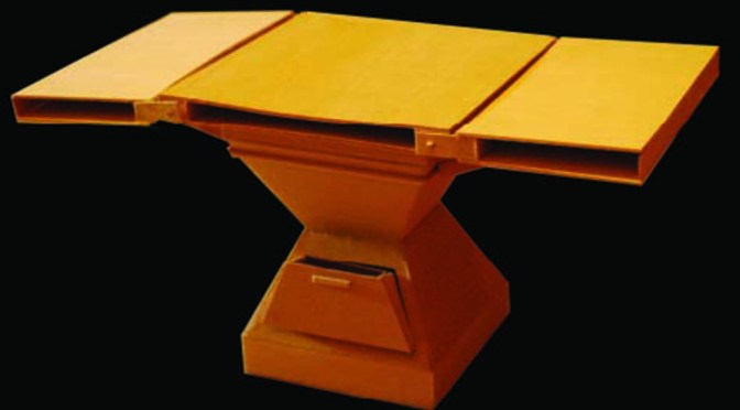
The scenario of a bachelor living in a small studio apartment in the East Village of New York City was the premise and inspiration for this table. The design is a reaction to the limited space in the apartment. Its features include two pocket sleeve drawers on opposite sides, spaces within the table tops for storage, and rotating table tops that allow for an extension of the surface to adapt to the user’s needs.

Reincarnating Waste Streams